
Ezigrade:
Designed for the farmer or land contractor. Ezigrade offers a simple and effective solution for Agricultural Land Grading, Land levelling and Tile Drainage.
Calculate a best fit single plane design or best fit multi-plane design. Alternatively you can calculate a land levelling solution by entering minimum amd maximum row and cross slope constraints. Optionally enter minimum or maximum field RL's. The surface produced can result in much lower volumes than a planar solution. Optionally smooth the surface produced. This can be done as part of a multi-section design.
Ezigrade contains routines for drain/ditch as well as banks.
Alternatively use Ezigrade for your Tile Drainage needs. Ezigrade has routines for pipe layout as well as designing and displaying pipe diameters.
Ezigrade understands many Ag proprietry files for your data conversion needs.
Leverage CDS and create drains, ring dams, farm roads etc as part of your design for a complete solution.
CDS (Civil Design and Survey)
Intelligent 2D & 3D Coordinate Geometry calculations to improve your design efficiency. It's Versatility will assist you with Title Surveys, Subdivision Design or Construction Site Design & Layout.
Model:
Terrain Modeling with Contours and Volumes. Interpolate Sections across any Model. Shade models by height and slope. 'Blend' models to create 'as-built' model simply.
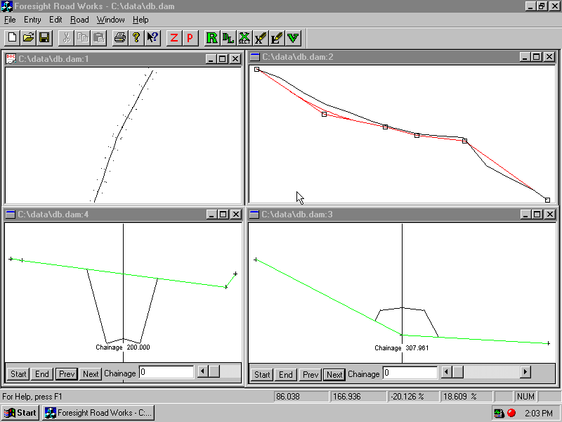
Road:
Design Roads. whether rural, urban, or highways using either section templates or design strings. Also used for other regular structures such as airfields, channels, conveyors, railways etc.
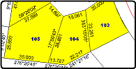
Misclose App:
An easy to use app to check lot closure and calculated area.
Bring up the DWG created by your favourite survey software. Click on the bearings and distances around the lot and check misclose and area.
Create a PDF report for Quality Assurance.
Civil Designs to Trimble Field Level II (Multiplane) Format
Let us transform your Civil Design (in DWG or LandXML) into Field Level II Format.
Price is $200. Pay after your design is tested. Click above to get lodgement instructions.
![[temporary image]](prolog1.gif)
Prolog:
Borehole logging just got a whole lot easier - simplified entry using your own templates means you get finished sooner, and Graphic Logs displayed as you go removes the errors.
Prolog comes supplied with a number of predefined templates. It also includes a template for the new Australian CoalLOg standard. Ensure your data is consistent with what the major Geological databases require.